
February

For the longest training run before my first 50 miler, I set out to run an out and back on one of my favorite ridge lines in the Smokies. To take any pressure off, and ensure as much fun as possible, I decided to run without a GPS watch or phone. Turns out one handheld wasn’t quite enough water for 24 miles, and I spent the second half of the run staring at the day hikers’ water bottles who I passed, and willing myself not to drink any unfiltered water from the streams.
March

-

- Just after leaving the 26 mile turn around. Fully realizing that I signed up for an out and back race


-

- Entering the throes of despair with about ten miles to go

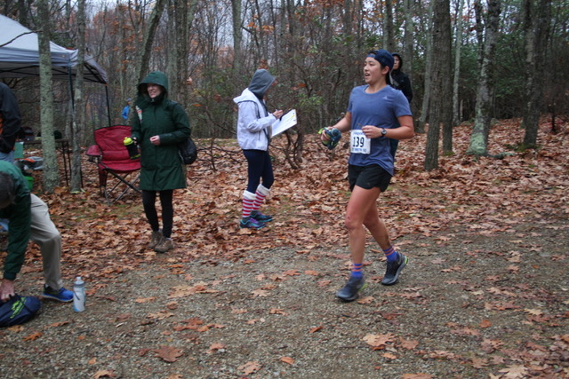
Bel Monte 50 Miler (Lyndhurst, VA). I had no idea what to expect from my first 50 miler. The first 26 miles before the turn around were awesome, since I got to cut loose and run as fast as I wanted to. I ended up running a lot of the race with seasoned ultrarunners Mike (pictured above) and Drew. They were just out there having fun. For instance, Drew was perfecting the skill of peeing while running, which really kept my mind off of the task at hand. Six of my friends came to the race to cheer me on for 10 hours, which is still mind boggling to me. Annie, Robin, Christina, Carly, Katie, and Nick, you guys ROCK. My whole body started to hurt with about ten miles to go, and I promised to myself I’d never run one of these things again.
-

- McAfee Knob – most photographed view on the AT

-

- Tinker Cliffs

Two weekends after Bel Monte, my friend Nick and I made plans to backpack the McAfee Knob section of the AT. He got sick one day before the trip, so I ended up going on my own and doing a short overnighter. I took a nap on a sunny rock at Tinker Cliffs, and then slept almost 12 hours in my tent that night. Which means I definitely spent more time sleeping than I did hiking this trip.
May


I headed to the Midwest in search of adventure for my birthday weekend. A friend from the PCT, Cameron, lives in Milwaukee, so we drove 6 hours north to the Upper Peninsula. There, we took a shuttle down to the southern end of Pictured Rocks National Lakeshore and backpacked the 40 some miles back to the car along Lake Superior. This hike had many unique features: plunging cliffs, large sand dunes, and forests full of ramps (the vegetable, not the concrete structure, c’mon people!). And I got to hike 24 birthday miles, thanks Cameron!
June

Rolled my ankle just after this picture was taken, due to running while staring at this spectacular view

-

- The kind of sunrise that makes you jump out of the tent

First long run back after Bel Monte. I wanted to go to the mountains, but only had 14 miles on the schedule, so I compromised and drove to Grayson Highlands since it’s one of the closest places to access the AT from Durham. Just so we’re all on the same page here – I drove 3 hours and 9 minutes to camp on Friday night and run 14 miles on Saturday. And it was totally worth it. The highlight of the run: I posed for a picture with one of the wild ponies that was a respectable distance away, and it slowly walked over to me and then start licking the salt off of my body.
-

- Hanging Rock State Park

-

- Pilot Mountain State Park

The next weekend, I checked out a state park I’d never been to before that is pretty close to Durham. I had high hopes for Hanging Rock, but ended up having a horrible morning there. I tried out using a Poptart as run fuel, and as it turns out, there’s a reason no one does that. It didn’t fit in any pockets, and it got progressively soggier in the humidity. So instead of being well fueled, I just looked like a weirdo running around with a Poptart in my hand. When I got to the high point in Hanging Rock, I looked off and could see Pilot Mountain in the distance, identifying my conquest for the next weekend.
Pilot Mountain ended up being even more miserable than my morning at Hanging Rock. Way back in college as a 19 year old, I ran the Pilot Mountain Marathon as my first foray into distance running. It would have been fun to revisit the memories and trails from the race, had it not been a morning with 99% humidity. I am not great in the heat (not yet, at least), so 20 miles with 4000 ft of gain really sucked the life out of me.


I often start hikes in the Smokies from the Big Creek campground, since it’s just a few minutes off of I-40. I love hiking to Mt Cammerer and Mt Sterling, but before this Saturday I had always done them separately. I decided it was time to link them, and what a loop it was! I started on the Chestnut Branch trail connector to the AT (steep), hit Mt Cammerer, descended via the Low Gap Trail, and started climbing towards Mt Sterling on the Swallow Fork Trail. The Swallow Fork Trail is pretty brutal in that it’s quite sustained and feels rather endless. When I finally arrived at Mt Sterling, the views were socked in with rain clouds. I halfheartedly ate a gel, bummed about the lack of views, and ran down the 6 mile Baxter Creek Trail on very shaky legs. All in all, it was 21 miles with 7000 ft of gain. Can’t wait to repeat this one day! I’m only able to say that because it’s been six months and I forget how hard it was.
July


-

- Thank you for letting me borrow your Garmin, Annie. I got you 996% of your daily step goal


I had high expectations for my first time at Mt Mitchell! I camped on Friday night pretty high on the mountain, and woke up a few times during the night feeling like I needed more oxygen. In the first mile of the run on Saturday, I slipped on some wet roots and hit my shin on a rock. This made me a little bit grumpy. Coupled with the coming heat and humidity of the day, I didn’t have an awesome time at Mt Mitchell. I had planned to run 30 miles, which would have been my longest training run ever, but I cut the day short at 25 miles. I went straight to Waffle House after running and ate a whole All-Star breakfast. I think I have since deleted the photographic evidence, since it was nauseating at the time and even more so in retrospect. Ultrarunning is a funny sport – driving home, I was disappointed in my 25 mile effort since I didn’t push myself to go the full 30. But if you zoom out a little bit, 25 miles is certainly something to be proud of.

Ran down Three Ridges (on the left), crossed the valley/Tye River, and went up the Priest
-

- Delightful little campsite

-

- Randomly ran into a good friend on the trail! Brought me out of my calorie deficient stupor


Two weeks later, I was ready for my next crack at the 30 mile training run. A local ultrarunning buddy told me about a two mountain circuit in Virginia (the Priest and Three Ridges) that East Coast ultrarunners sometimes do in preparation for big races out west. He suggested I park at the Tye River, which is located in between the two mountains, and run up and down each individually. This way you can restock from your car halfway in between and jump in the river when you’re done. Of course, for a number of reasons that don’t really make much sense, I decided to do it a more convoluted and logistically difficult way. I started from Reids Gap and the plan was to run south along the AT – down Three Ridges, across the Tye River, up the Priest, and then retrace my steps back to my car. Thanks to the heat and humidity and difficulty of this route, I only made it halfway up the Priest before turning around. I was starting to feel really funny (dehydration? hyponatremia? exhaustion?) and wanted to make sure I’d be able to make it back to the car. I was also trying to be back to Durham in time for a 6pm dinner. I was so spent from this effort that I wasn’t even all that disappointed that I quit 7 miles short of my goal.

Two more laps around Pilot Mountain (20 miles and 4000 ft of gain) to round out July. This Saturday was certainly more enjoyable than the outing with 99% humidity, although I do remember sitting down on a rock shortly before I took this picture and feeling a real lack of desire to do a second loop up and down the mountain (read: tears). Ate a gel and instantly felt better.
August

First weekend of August: White River 50 Miler in Washington! Great day, which you can read about here.


Two days after White River, I joined another friend from the PCT, Dylan, in Glacier National Park for a few days. The first day, we went on a 9 mile point to point hike through Siyeh Pass. I was so blown away by the scenery in Glacier! Dylan can confirm, but I think I spent most of this hike saying things like “this can’t be real” and “whaaaaaaat.”

The Skyline Experience route
-

- Checking and rechecking internet directions to make sure we had to go straight over this thing. Seems obvious now

-

- Cracker Lake from above! Mt Siyeh looms in the distance

-

- Dizzying views from the summit of Mt Siyeh (10,014 ft)


Photo credit: Dylan Harris

Standing closer to the edge than I wanted to. Mt Siyeh still looming in the background, kind of like that mandatory, massive task on your to do list that you’ve been dreading all day, and it’s almost time to do it. Photo credit: Dylan Harris
For Mom and Dad: the second day in Glacier was really fun and we had a great time hiking in the sunshine. Now skip on down to the Vancouver entry.
For everyone else: Dylan and I spent an hour in a coffee shop deciding what part of the park we wanted to explore on my last day there. I somehow got it in my head that I wanted to get on top of something, so I started googling things to summit in Glacier. Thus, I discovered the Skyline Experience – an 18 ish mile off trail route originating at the Many Glacier Hotel that follows an amazing ridge line and summits Wynn Mountain, Peak 9190, Cracker Peak, and finally Mount Siyeh. We took screenshots of the thorough directions on the internet and set off for Many Glacier, after confirming that we didn’t need any real gear. This was my first time hiking off trail and route finding. At times it was a terrifying introduction to class III and IV scrambling. Because as I found out, even though a route says it contains only class III scrambling, you have to be able to find that class III line, otherwise it becomes class IV. Three excerpts from the directions which I found horrifying at the time but now just make me chuckle and also start sweating a little:
“After plodding up the talus for 20 minutes or so, the cliff band will be encountered. Look for a loose, class III gully that bisects the cliffs.” There were lots of gullies to choose from…
“At this point, trend to the south (pretty self-explanatory here, as a detour to the north involves tremendous cliffs and frightening exposure) and look for a well-worn trail that gives access to a short, enjoyable class III route to the top.” Tremendous cliffs and frightening exposure: confirmed.
“Ultimately, the talus field will come to a terminus at a large cliff band. You are looking for a broad, loose, class III couloir; if it appears too steep, you are too far north, and need to work your way south along the top of the cliffs until the correct couloir is located.” It’s really hard to decide what is ‘too steep’ when everything looks too steep. Also…remind me which way is north again?
Needless to say, the 2000 ft descent on talus and shale did not feel good on the knees four days after running a 50 miler. Thanks for being game for an adventure, Dylan!


Visited with my cousin Stuart and Maria in Vancouver! In addition to eating delicious food (authentic ramen YES) and cooking elaborate dinners with Maria (low country boil YES), Stu and I decided to race up Grouse Mountain via the Grouse Grind, which is a 2.9 km trail (we’re in Canada now) straight up stairs cut into the mountain. Stu beat me up, but only just barely. Now I have a reason to visit again.

A wonderful weekend car camping with Annie in the Smokies. On Saturday morning, I drove to the Alum Cave trailhead and jogged the 5 mile trail up to Mt LeConte, drank 5 cups of lemonade at the lodge, and then barreled back down. Little did I know, I’d be headed back up to Le Conte a few months later…
September

Favorite spot in the Smokies. This is it, folks.


Cameron drove down 11 hours (one way!) from Milwaukee to the Smokies for a Labor Day adventure. Since he was driving so far, and since he’d never been this far south or east before, I was really excited to put together an epic backpacking loop. The fact that 74 miles was too much for three days slowly dawned on me with each step that we hiked. Low point: it rained the whole second day. High point: views on views, and bringing a Red’s Quality Acre jalapeno with me – that thing was HOT.

-

- Sometimes all you can do is kick up your feet and sigh


-

- Of course I did.

I’d heard from a random day hiker I encountered earlier in the summer that I needed to check out the AT section around Roan Mountain. I did just a little bit of research, and drove to the spot where the AT crosses the road near Roan Mountain. I then proceeded to go the wrong way on the AT, and ended up camping with a group of 8 surprisingly rambunctious 60+ year old men. It is very hard to go the wrong way on the AT. However, I’m still confused about which direction is which at that trail junction. Anyways, the next day’s run was awesome! I got to see my first cloud inversion on the East Coast, and met a fellow ultrarunner named Scott. Ran for 20 miles with 5000 ft of gain. I will definitely be going back to Roan Mountain, and the area south/north of it.

View of Mt Sterling from a sweet campsite that I will come back to one day


I had also heard great things about Max Patch, so the next weekend I drove west to the spot where the AT crosses I-40. I started 12 miles or so south of Max Patch, and ran north along a surprisingly challenging ridge line. After spending 5 minutes on Max Patch eating a Payday bar watching people watch the clouds go by, I rolled on back to the car in search of a gas station coconut water. All in all, a solid day with great views and 25.5 miles with 7600 ft of gain.
October

-

- Breaking down camp. Good or bad omen?


-

- Nice and woodsy with a side of exhaustion

Spoiler alert: third time was the charm for completing a 30 mile training run. I went back to the Three Ridges/Priest linkup, and this time cooler temperatures aided me in making it all the way up the Priest before turning around. Man, it was hard. There is only one part that I remember vividly. Partway up the Priest, I stopped abruptly, put my hands on my knees, and heaved a deep sigh. That sigh turned into a really pathetic, desperate noise when I realized there was a big snake a foot away on the trail. I backed up and I tried throwing two rocks at it, the first of which went sailing over thanks to adrenaline. The snake didn’t move. Was it dead or just sleeping?? I very maturely bushwhacked in a large arc around the snake and continued on my way. I finally finished the Three Ridges and Priest run for a total of 30 miles and 10,200 ft of gain!


While visiting Asheville with my dear friends Luke and Christine, I took my third-wheeling self on a Saturday morning run in the Smokies. Starting from the Smokemont campground, I ran up the Dry Sluice Gap Trail and then north on the AT before turning around and heading back down. The fall colors were just gorgeous. This was a morning when 20 miles with 4600 ft of gain felt very comfortable, which is a weird sentiment.
November
Putting all the training to work at the Mountain Masochist 50 Miler! Read more about it here. If you can’t tell, I’ve used all the flattering pictures already and we’re left with this one.

Tinker Cliffs

-

- Sunrise at McAfee Knob


-

- COWS

-

- Nick’s safety orange pack cover

-

- North Mountain Trail visible on the left!

During Mountain Masochist, Anna told me about the Virginia Triple Crown loop, which combines McAfee Knob, Tinker Cliffs, and Dragon’s Tooth in about 35 miles. Nick and I decided to give it a shot! There were still some fall leaves up on the trees, and we had some great weather. My favorite part of the trip was the North Mountain Trail, which is located across a valley from the AT, due to its remote feel and views down into the valley. I will definitely be coming back to do the loop as a run one day!
December

“Sunsets and Self Care” Photo Credit: Seth Orme
-

- Heavy pack and snow on the AT

-

- Exhibit A: icy trails


For the final adventure of 2017, I went back up to the Mt LeConte Lodge where a friend from the PCT, Seth, is serving as the winter caretaker. Mt LeConte is only accessibly by trail, the shortest of which is 5 miles long, but I decided to take the long way up, starting from 16 miles away at the Smokemont campground. Seth mentioned that veggies and beer are always appreciated, so I packed up 12 beers, brussel sprouts, an onion, two sweet potatoes, an avocado, two jalapenos, broccoli, a block of cheese andouille sausage, a grapefruit, and slice and bake cookies. Highlight of the weekend was a 16 mile run straight down the mountain (via Rainbow Falls Trail) and then straight back up (Trilllium Gap) in which I tried my darnedest to keep up with Seth on some really icy trails. Fellow thru hiker Neemor joined for the weekend as well, and we all had a great time talking about gear and trails and adventure, as well as watching some unforgettable sunrises and sunsets. Neemor created an awesome video about the weekend – watch it here!
If you’ve made it this far, you’re the real hero. Please go take a break from your computer, and thanks for reading!


notANNIE
December 23, 2017 at 4:16 pmIs Annie your girlfriend? She comes up a lot in these posts who is she?
Leah Ling
December 23, 2017 at 8:15 pmWouldn’t NOTANNIE like to know…
Diana
December 24, 2017 at 9:39 amhahaha NOTANNIE
Leah I love reading these posts! I can’t wait to see what you get up to next year, please keep taking pictures and writing about your life in the mountains 😀
Leah Ling
December 24, 2017 at 4:48 pmThank youuuu Diana! Congrats on getting that first 7a!!
Drew
January 1, 2018 at 8:21 pmI suggested to my friend that she do White River 50 this year as a training run before her first 100 (Mountain Lakes), and I remembered that you wrote a race report on it… So that brought me here, and to the line about me practicing peeing and running. Hahahaha! I still haven’t figured it out. Maybe it’s best just to stop. At least when it’s 10 degrees out and your wet shorts start to freeze. Happy New Year!!! Good luck in 2018 and hit me up if you head out this way!!!
-Drew
Leah Ling
January 1, 2018 at 8:56 pmHahah I will never forget the peeing while running! I loved White River – if your friend has any questions about the course let me know! And good luck to you as well in 2018. Hopefully I will make it out to the West Coast sometime.